![]() Japantown
Atlas - Northern California - Oakland and Alameda
Japantown
Atlas - Northern California - Oakland and Alameda
Overview Map: Oakland and Alameda Japanese American
Businesses of 1940 with an inset of Alameda's Park Street.
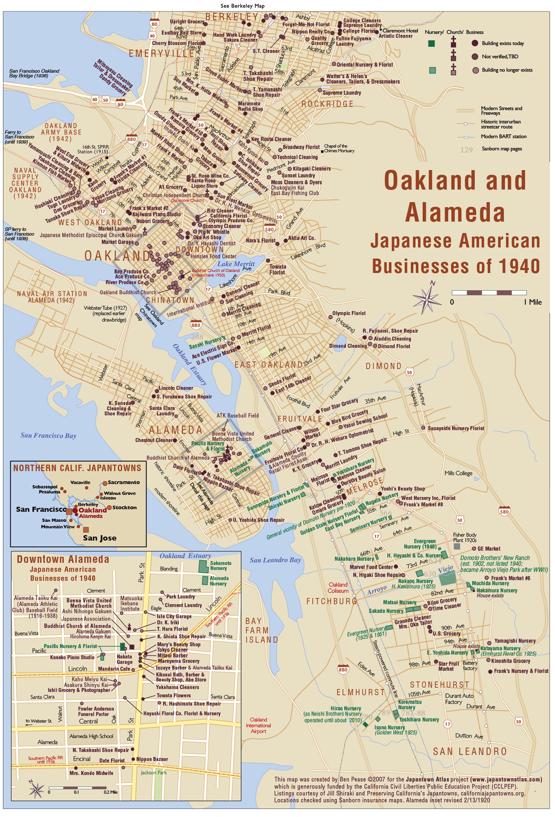
Oakland had a large and complex Japanese American community, which grew considerably after the 1906 earthquake and fire in San Francisco. Nikkei and non-Nikkei refugees took up residence in the East Bay and many set down roots there. The main Japantown was in Chinatown, centered on 8th and Webster Streets. Outside of downtown Oakland had numerous mom-and-pop sized businesses up and down the major streets and streetcar lines – Telegraph Ave, East 14th Street, and San Pablo Ave.There were Buddhist churches in both Oakland and Alameda, both of which worship today in their original buildings. Oakland's church was purpose-designed by architect George Shintoku Shimamoto (architect of the San Jose and San Francisco churches); Alameda's church occupies a donated Victorian mansion. There were also several Christian churches (Buena Vista United Methodist Church continues in its original location with the old church used as a social hall).
Preserving California's Japantown data shows that a relatively large percentage of Oakland/East Bay landmarks survive in 2008, mostly ordinary streetcar-era storefronts.
Alameda had a rather large Japanese American merchant presence on Park Street, serving its working- and owning-class populations, and perhaps also serving the local Japanese American population in adjacent East Oakland. The business district was more diverse in the 1920s than in 1940 by which point immigration restrictions had slowed new arrivals and folks who stayed had figured out which businesses work. See markers at Alameda Public Library and Park St. Market in Alameda for newer maps.
East Bay Flower Nurseries:
On the Oakland map I've shown nurseries in green, with the actual properties
outlined. Seeing all these nurseries mapped out, they are quite impressive.Oakland
was the center of the Japanese American flower nursery industry in the East
Bay, which extended from Richmond and El Cerrito to San Leandro and Hayward
(and also on the San Francisco Peninsula). The 1940 directories list nurseries
in many Bay Area cities, but Oakland's nurseries are the easiest to
map, as they all had street addresses in 1940 (whereas those in rural areas
still had rural delivery route or PO box addresses). So it was possible to find
the corresponding Sanborn pages and look for extant structures (or what replaced
them) on satelllite photos. Many of the nurseries are on creek bottoms,
where there was good groundwater; most are near historic railroad and streetcar
lines, which provided direct access to Oakland and San Francisco (via connecting
ferry).
One nursery NOT listed in 1940 was Domoto Brothers, a huge operation which trained so many future East Bay growers it was sometimes called "Domoto College." Starting in West Oakland near the turn of the century, the Domoto brothers relocated to East Oakland around 1910, and their operation grew to 40+ acres with 3 dozen greenhouses. On the 1924 Sanborn map it covers an entire page! Sometime in the late 1930s they quit operation, and soon after (by the early '50s) the Domoto land became Oakland's Arroyo Viejo Park. The rustic stone bridge over the burbling arroyo may be the old nursery entrance; near the park's southeast corner a row of cypress trees were originally a windbreak around one of the Domoto residences or dormitories.
Very few Oakland nurseries survive today (2008). The postwar housing boom, rising land prices, and other factors have led to most being developed. Frank's Nursery (Gomez Nursery) at 9875 MacArthur Blvd in East Oakland was closed; the stand was derlict but extant in 2007. Neishi Bros. Nursery (formerly Hirao Nursery) still operateed a 3.8-acre farm on East 105th Ave. in 2006; they were kind enough to let me visit their operation, now run by the 4th generation of the family. It closed a few years later, but the main buildings remain standing as of 2020. The Korematsu and Yoshihara nursery sites on Edes Ave. have been gone for a while, but the cleared lots are being developed with a Habitat for Humanity housing project. The dwellings for the Katayama and Nakamura nurseries were also extant in 2008, even though the adjacent nursery land has been developed.
revised 10/14/25
Notes: Japanese American busineses in Downtown
Oakland and Chinatown
are so dense they are shown here only with dots - see that
map for names. The top of this map overlaps with our Berkeley
map. Download a PDF of Oakland/Alameda/Berkeley
(3 pages, 620 kb).